Directions
OLD SPRING FARM BED & BREAKFAST
Not quite Ferrum (15 mi. East) and not quite Woolwine (8 mi. West)
P.O. Box 3, 7629 Charity Highway, Woolwine, Virginia (VA) 24185-0003
Phone (276) 930-3404
From Blue Ridge Parkway (BRP)
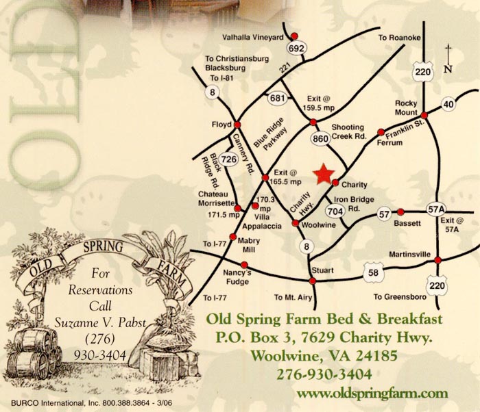
From North: Exit at milepost 159.4. Left on Rt. #860 Shooting Creek SE. Experience the 6 mile wind down this road made famous in song and bootleg liquor lore. Turn right onto Rt. #40 West, Charity Highway, for 3.7 miles to Old Spring Farm on right.
From South: Exit Floyd, Rt. #8 South 6 miles to Woolwine. Turn left onto Rt. #40 East, Charity Highway, toward Ferrum. Go 8 miles to Old Spring Farm on left.
From I 77: 1 hour
From North: Exit at Rt. #148 at Fancy Gap, follow signs for BRP North. Follow above instructions from BRP South.
From South: Exit Rt. #89 Mt. Airy. Take 89 East to Rt. #103 East to Rt. #8 North to Woolwine, VA. Turn right onto Rt. #40 East, Charity Highway. Go 8 miles to Old Spring Farm on left.
From I 81 North: 50 miles, 1 hour 20 minutes
Exit #143 at Roanoke. Take combined Rt. #581/220 South 24 miles to Rocky Mount. At Rocky Mount, take Ferrum College Exit onto Rt. #40 West. Pass Ferrum College, proceed 15 miles. Old Spring Farm is on right.
Alternative: 1 hour 30 minutes. From Roanoke take 581/220 South to the Blue Ridge Parkway South. Follow above directions from BRP North.
From I 81 South: 37 miles, 45 minutes
From Christiansburg: Exit Rt. #8 Floyd Exit. Take Rt. #8 through Floyd to Woolwine. Turn left onto Rt. #40, Charity Highway. Go 8 miles to Old Spring Farm on left.
From North Carolina: 75 miles from Greensboro Airport, 1 1/2 hours
Rt. #68 to 220 North toward Martinsville. At Ridgeway, VA. take 220 North toward Roanoke, bypassing Martinsville (9.5 miles), Exit #57A Fieldale/Bassett. Go left to Bassett (4 miles) junction with Rt. #57. Go 12.8 miles to State Road #704 (Rt. 704 is Iron Bridge Road) (704 is 2nd right after Fairystone State Park turnoff). Go 6.7 miles on #704 to stop sign. Turn right onto Rt. #40, Charity Highway, toward Ferrum. Go 1.7 miles to Old Spring Farm on left.
Visitors and residents of Virginia may access businesses via the Internet I-81 Traffic and Travel Info www.511Virginia.org or through landline and wireless phones (800-578-4111). Weather alerts, traffic incidents and road closings offer motorists instant information using a voice-activated phone system. Motorists driving through the Shenandoah Valley may obtain information on lodging, dining, attractions, tow trucks, convenience stores and rest areas while en route to their destination. This information may be obtained by either mile marker or city name.
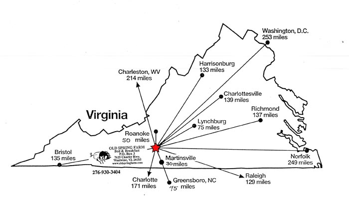
Approximate distance from
| Blacksburg, VA | 45 miles |
|---|---|
| Charlotte, NC | 3 1/2 hours |
| Christiansburg, VA | 40 miles |
| Ferrum, VA | 15 miles |
| Floyd, VA | 15 miles |
| Hillsville, VA | 1 hour |
| Raleigh, NC | 4 hours |
| Richmond, VA | 4 hours |
| Roanoke, VA | 50 miles |
| Stuart, VA | 24 miles |
| Washington, D.C. | 6 hours |
Do not use Microsoft or Map Quest map. They are not accurate in the mountains.